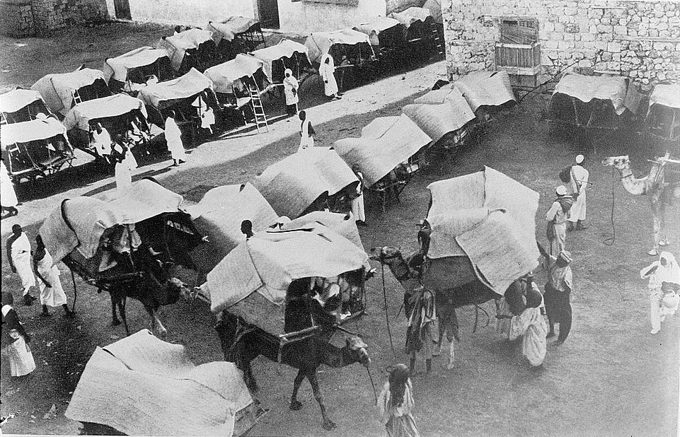
Navigating the Geography of Reaching the Sacred: The Seven Pilgrimage Routes—A Yearning to Reach the Sacred House of God from All Directions
This is the geography of reaching the sacred, where the Sacred House of Allah stands and pilgrims circumambulate the Kaaba to perform the Hajj with all its rituals. This ancient geography passes through trails, pathways, hills, and sand, across deserts and wilderness, plains and vast expanses. This entire journey, once undertaken by tribes and groups of pilgrims from various Arab and Islamic countries, gave rise to a great cultural tradition that continues to this day: the culture of Hajj.
Before the Kingdom of Saudi Arabia developed the means of reaching Makkah and expanded the Grand Mosque on an unprecedented scale in history, another culture began to emerge: the culture of technology, speed, and facilitating pilgrims’ arrival at the Sacred House. So, what was the geography of these journeys like in the past, and what were the most prominent routes leading to the Holy Kaaba?
The route taken by Prophet Muhammad, peace and blessings be upon him, and his Companions during the Conquest of Makkah in the eighth year of the Hijra is considered the first route to the Grand Mosque between Madinah and Makkah in the Islamic era. As the Islamic territories expanded, the need arose to extend the network of Hajj and trade routes.
Seven Routes:
The ancient Hajj routes served as bridges connecting the cities, countries, and regions of the Islamic world. Through them, knowledge was exchanged and Muslim communities across different parts of the world maintained contact, whether through cultural or economic interaction. Since Allah made Hajj obligatory for Muslims, caravans of pilgrims traveling to the Sacred House of Allah have followed these routes, answering the call and directing their journeys toward the Ancient House. Their hearts longed to perform the fifth pillar of Islam, and pilgrims arrived from every distant place.
Historical sources have preserved records of seven major routes that connected various parts of the Islamic state to Makkah and Madinah. These were:
First: The Kufa–Makkah Route
This was one of the most important Hajj and trade routes during the Islamic era. It became known as the “Darb Zubaydah” (Zubaydah Trail), named after Lady Zubaydah, the wife of Caliph Harun al-Rashid, who contributed to its development, ensuring that her name would be remembered throughout the centuries.
The route came into use following the conquest of Iraq and the spread of Islam eastward. It began to flourish during the era of the Rightly Guided Caliphs, and its use became regular and considerably easier, as water sources, grazing areas, and mining sites along the route were transformed into major stations.
Historical and geographical sources indicate that the route was planned according to a unique practical and engineering design. Stations and rest areas were established along its length, and its surface was paved with stones in sandy and muddy areas. It was also equipped with the necessary facilities and services, including wells, reservoirs, and dams.
Markers and fire beacons were also installed to indicate the route and guide travelers. At the beginning of the Abbasid state, Caliph Abu al-Abbas al-Saffah ordered the placement of milestones—stones marking distances—and signposts along the entire route from Kufa to Makkah in 134 AH / 751 CE.
The route had twenty-seven main stations, along with an equal number of secondary stations, each known as a “muta‘ashsha.” These were rest stops established between every two main stations. The route also had several branches, including the Ma‘dan al-Naqrah–Madinah route, which extended for 265 kilometers. Its most important stations included Al-Usaylah, Al-Muhdath, Batn Nakhl, Al-Husaylik, Al-Makhulayn, Al-Suqrah, Al-Turuq, Al-Rukabiyyah, and Madinah. The Basra route also joined the Kufa route at Ma‘dan al-Naqrah.
Second: The Basra–Makkah Route
This was the second most important route. It began in the city of Basra and passed through the northeastern Arabian Peninsula via Wadi al-Batin, crossing several desert regions, the most difficult of which was the Al-Dahna Desert. It then passed through the Al-Qassim Region, which is rich in fresh water, fertile valleys, and springs. From there, the route ran alongside the Kufa–Makkah route until the two met at the station of Umm Khurman, also known as Awtas, located ten miles from the site of Dhat Irq.
The Basra route joined the main route extending from Kufa at Ma‘dan al-Naqrah, from where a branch led toward Madinah.
The route was approximately 1,200 kilometers long. Today, only a few wells, dams, and abandoned palaces remain as traces of it. Important remains can be found in the Al-Qassim Region. In Al-Asyah, the ruins of a large stone-built palace remain, including remnants of semicircular arches. Nearby are traces of springs, ancient channels, reservoirs, and dams. In Dariyah, the remains of the old settlement are still visible.
Third: The Egyptian Hajj Route
This route was used by pilgrims from Egypt, along with those accompanying them from the Maghreb, Andalusia, and Africa, as they traveled toward Makkah. They headed across the Sinai Peninsula to reach Ayla, now known as Aqaba, which was the first station on the route. After Ayla, the pilgrim caravans passed through Haql, then Al-Sharaf, and then Madyan, known as Mughair Shu’ayb or Al-Bad‘.
Pilgrims continued traveling along the coastal route until the middle of the fifth century AH. They then switched to sea travel via the Aydhab route because of events that took place in Egypt during the Fatimid period.
The coastal land route continued to serve Egyptian pilgrim caravans until 1310 AH. After that date, Egyptian pilgrims once again traveled by sea, sailing from Suez to Jeddah aboard steam-powered and sailing ships.
The Egyptian Hajj route received considerable attention from Muslim rulers during the early Islamic period. They built reservoirs, dug wells, made difficult sections of the route easier to cross, and constructed mosques at some of its stations. Khumarawayh ibn Ahmad ibn Tulun, for example, cleared the rocky Aqaba Pass.
Hundreds of Arabic inscriptions have been found along this route, carved by pilgrims into rocks at its stations and along its course as reminders of their passage. Architectural remains from that period can also be found along the inland route, including Birkat al-Nabi‘, south of the city of Duba, Birkat Bada, and the wells of Balata. Other remains lie along the coastal route, including Birkat Madyan and Birkat al-Jar. In addition, several cities and settlements once flourished along the route, including Madyan, Aynuna, Al-Awnid, Al-Hawra, Al-Jar, Al-Juhfah, Shaghb, and Bada.
Fourth: The Syrian Hajj Route
The Syrian Hajj route connected the Levant with the holy sites in Makkah and Madinah. It was also known as the Tabuk Route because it passed through the town of Tabuk.
The route began in Damascus and passed through Bosra al-Sham, in present-day Daraa, as well as several other settlements, the most important of which were Adhri‘at, Ma‘an, and Al-Mudawwarah, also known as Sargh. It then entered the territory of the Kingdom of Saudi Arabia, passing through Halat Ammar, followed by Dhat al-Hajj in Tabuk, then Al-Aqra‘, and Al-Akhdar, where the Al-Muhdathah station was located. From there, it continued to Al-Mu‘azzam, Al-Hijr, AlUla, and finally Qurh.
Fifth: The Yemeni Hajj Routes
The Yemeni Hajj routes were among the routes that connected Yemen with the Hijaz from ancient times. Pilgrims from Yemen traveled along three routes: the coastal route, the inland or central route, and the upper route. Each had its own paths, stations, and difficulties, which pilgrims endured for centuries.
The route ran from Al-Sharjah to Al-Mufjir, then to Al-Qunaydirah, followed by Athar, Bayd, Al-Duwaymah, Hamdah, Dhahban, Halin, and then Qarma and Dawqah, reaching Al-Surayn, where the coastal and inland routes met. From there, they diverged again, each continuing in its own direction. The coastal route headed toward Al-Lith, then Al-Shu‘aybah, and onward to Jeddah before reaching Makkah.
Among the routes preferred by pilgrims traveling from Yemen to the Sacred House of Allah was the route that passed through northern Yemen and crossed the mountainous Asir Region before reaching Taif and then Makkah. Although the route traversed areas with difficult terrain, it was favored by pilgrims and other travelers because it passed through fertile, evergreen lands, villages, and towns where water was available and food was plentiful.
Sixth and Seventh: The Two Omani Hajj Routes
These were the two routes used by pilgrims from Oman to reach the holy sites. One route led from Oman to Yabrin, then to Bahrain, from there to Al-Yamamah, and onward to Dariyah.
Geographical sources indicate that Dariyah was a meeting point for pilgrims arriving from Basra and Bahrain. After completing the Hajj, they would separate as they began their return journeys: pilgrims from Basra headed north, while those from Bahrain traveled toward the right. Caravans arriving from Oman could also cross the Al-Ahsa Region to join the Al-Yamamah–Makkah route.
A Cultural Role
One outcome of the movement along Hajj and trade routes was that it attracted travelers and explorers to the Arabian Peninsula. The historical road network was first depicted graphically in the sixteenth century in the Map of the Three Arabias by the French geographer Nicolas Sanson, who illustrated the stages of the journey to Makkah, inspiring further exploration and travel.
Because Makkah and Madinah are sacred cities whose entry is restricted to Muslims, some travelers driven by curiosity embraced Islam so that they could reach the end of the route and complete the Hajj journey.
Today, Hajj has become easier for those wishing to undertake it, thanks to modern means of transportation by land, sea, and air. The Kingdom of Saudi Arabia has mobilized all its resources to provide a wide range of services across different sectors for the Guests of the Most Merciful. These include the expansion of the Two Holy Mosques and the development of the sacred sites, such as the Jamarat Bridge and the Mashair Train, in ways that make every Muslim proud.
Transportation facilities have also advanced, most recently with the Haramain High-Speed Railway connecting Madinah and Makkah. Other services include the provision of cold drinking water everywhere, food supplies, suitable accommodation, and cooling systems throughout the sacred sites and their roads. These efforts also extend to security and safety, as well as healthcare services, all of which are provided free of charge.
Ensuring the comfort of the Guests of the Sacred House of Allah remains a constant and enduring priority for the Kingdom across all sectors serving Hajj pilgrims.
Footnotes:
· https://www.al-jazirah.com/2024/20240628/ld1.htm
· https://www.spa.v.sa/1e707e73aa#95f1d43eb3